Many different people and landscapes define the USA; it is both diverse and large in both aspects. The USA’s map which shows 50 states and numerous cities in all kinds of regions, is more complex than just showing dividing lines and place names. It describes how people have moved, found opportunities, come together and created a diverse community.
We’ll look at the design of the United States, pointing out the important areas, highlighting each state’s significance and describing the special qualities of its main cities. If you’re going on a road trip, studying maps for a geography quiz or just want to understand the United States, this article shares a detailed guide about the country’s layout.
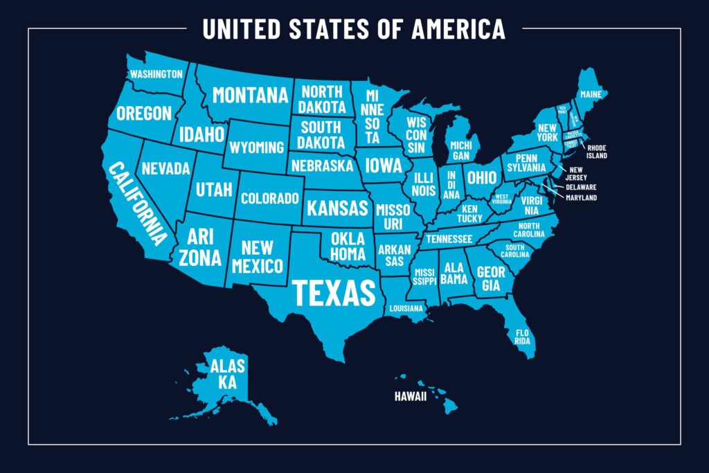
Understanding the US Map: A 50-State Puzzle
The United States is made up of 50 states, every one of which has its own government, culture and local taste. The main regions in which these states exist are six in number.
- Northeast
- Midwest
- South
- West
- Alaska
- Hawaii
Each region plays a crucial role in the nation’s identity and economy.
The Northeast: Cradle of American History
It’s called the birthplace of America for a reason, the Northeast. From a trivia point of view you’ll probably find it interesting that Massachusetts, New York and Pennsylvania were very important as far as the American Revolution and America’s early days were concerned.
New York City, in southeastern New York, is the largest city in the US; it is a global centre for finance, media and culture.
Of colonial history, Boston, in Massachusetts, abounds in landmarks like the Freedom Trail, as well as Harvard University.
The Northeast has four seasons with especially colorful falls, historic towns and Ivy League schools.
The Midwest: America’s Heartland
The Midwest which is sometimes called “America’s Breadbasket,” is home to Illinois, Ohio, Michigan, Minnesota and Iowa. This area is distinguished by:
- Fertile farmlands
- Industrial cities like Chicago, Detroit, and Cleveland
- The Great Lakes, which provide shipping routes and stunning landscapes
In the US, only Los Angeles and New York City are larger than Chicago, Illinois which is a hub of architecture, business and culture.
Another thing the Midwest is famous for is kind-hearted people, strong values and a key impact in politics.
The South: A Blend of Tradition and Growth
Texas, Florida, Georgia, North Carolina and Tennessee are all states that make up the South. The South is associated with friendly people, tempting cuisine and musical backgrounds and it also quickly nears modernity.
- Atlanta, Georgia is a booming business hub and home to global brands like Coca-Cola and CNN.
- Nashville, Tennessee, and New Orleans, Louisiana are famous for their contributions to country and jazz music.
- Texas, the second-largest state, is a powerhouse in both oil and technology industries.
Outstanding sites like the Appalachian Mountains and Gulf Coast beaches make the South special.
The West: Land of Mountains and Innovation
Key states in the Western region are California, Washington, Oregon, Colorado, Utah and Nevada. Because of its beautiful landscapes and new technologies, the West draws both adventurers and entrepreneurs.
- California alone is the most populous state and the fifth-largest economy in the world if it were a country.
- Los Angeles is the entertainment capital of the world.
- San Francisco is synonymous with tech innovation and progressive culture.
- Colorado and Utah are known for their mountain resorts and national parks.
- Las Vegas, Nevada is a world-renowned destination for nightlife and entertainment.
There are also many of America’s greatest sights in the West, including the Grand Canyon, Yosemite and the Pacific coastline.
Alaska and Hawaii: Outliers with Unique Charm
While not connected to the mainland, Alaska and Hawaii play unique roles in the US map.
- Alaska, which is in the far northwest of North America, is the largest state in the country. Canada is famous for its glaciers, abundant wildlife and rough landscape. The population center of Alaska and its capital are in Anchorage and Juneau, respectively.
- Hawaii, which lies in the central Pacific as a series of islands, is well known for its warm climate, beaches and stunning volcanoes. The culture is sweeter because of its strong Polynesian foundation.
Both states offer natural beauty and cultural richness that are distinctly different from the mainland.
Major Cities That Define the US Map
In USA MAP Even though all cities have unique charms, some cities are noticed for their big populations, strong cultures or great economies.
- New York City (NY) – Global finance, arts, and media
- Los Angeles (CA) – Entertainment and creativity
- Chicago (IL) – Architecture and transportation
- Houston (TX) – Energy industry and diversity
- Phoenix (AZ) – Rapid growth and desert beauty
- Philadelphia (PA) – Historic significance
- San Diego (CA) – Beaches and biotech
- Seattle (WA) – Technology and coffee culture
- Miami (FL) – Latin American influence and tourism
- Washington, D.C. – Nation’s capital, politics, and history
They support the nation’s identity at home and abroad by influencing culture and the economy.
Regional Differences: Geography and Climate
The USA covers a vast area and includes nearly every type of climate and landscape:
- Mountains: The Rockies, Sierra Nevada, and Appalachians
- Deserts: Found in Arizona, Nevada, and parts of California
- Forests: Cover large portions of the Pacific Northwest and New England
- Plains: Stretch through the Midwest and central parts of the country
- Coasts: Both the Atlantic and Pacific offer beaches, cliffs, and harbors
These regional differences affect everything from lifestyle and housing to politics and cultural norms.
Why the USA Map Matters
Gaining knowledge of the United States isn’t simply memorizing the cities or since places. It’s about:
- Appreciating the cultural and regional diversity
- Understanding migration patterns and historical events
- Navigating economic hubs and travel routes
- Gaining insight into local laws, customs, and dialects
If you are a student, traveler or a businessperson crossing state borders, learning about the USA’s geography improves your knowledge and choices.
Final Thoughts
In the United States, places are diverse yet they are related to each other. All the states and cities in the country help build the rich and diverse culture of America, from busy skylines to peaceful nature. On a map of the USA, you see the geography as well as the unbreakable union of people standing together with deep respect for their diversity.
Anywhere you go, in cities or in the open countryside, America is full of things to find out.
